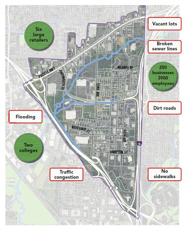
The Tigard Triangle is located in the northeast corner of the city, just east of Downtown Tigard. Its name comes from the triangle that is created by the roadways that surround it Highway 99W (Pacific Highway), Highway 217, and Interstate 5.
At about 550 acres, roughly the size of Downtown Portland, the Tigard Triangle is full of potential, but lacks basic infrastructure. The Triangle has the ability to support future growth but needs help overcoming the existing development barriers.
Development barriers include:
- Lack of walkability
- Lack of housing
- Lack of neighborhood uses/services
- Vacant lots
- Flooding
- Traffic congestion
- Broken sewer lines
- Zoning and development code issues
Several methods were identified to help overcome these barriers, including voter approval of a TIF District, adoption of a Vertical Housing Development Zone and adoption of an innovative set of development regulations known as the Lean Code.

Tax Increment Financing (TIF) District
The Tigard Triangle TIF District was approved by voters in May 2017 as a strategy to remove barriers to development and build projects that implement the vision by utilizing tax increment financing (TIF) as a source of funding.

Projects for the Tigard Triangle TIF District are divided into six categories, however more work needs to be done to prioritize projects and develop strategies for achieving the plan's goals.
The categories include:
1.) Transportation - these projects will provide a safe and effective multi-modal transportation network that provides access to, from, and within the Triangle and support mixed-use and pedestrian-oriented development.
2.) Public Utilities – these projects will be used to provide public utility improvements to support desired development. Projects will address infrastructure deficiencies including the construction of new stormwater facilities, repair of existing sewer lines, and extension or enlargement of existing water and sewer lines as needed to support desired development.
3.) Public Spaces, Facilities and Installations - these projects will create a clear identity for the Triangle as a fun and diverse place to live, work, shop, eat, and play by building upon existing unique and desirable features. Projects will include parks, greenways, trails, recreation facilities, plazas, public restrooms, art and wayfinding signage.
4.) Re/Development Assistance and Partnerships - these projects will provide financial and technical assistance to new and existing businesses and housing developments that contribute to the Triangle’s diversity and vitality and help it transform into a mixed-use and pedestrian-oriented district.
5.) Project Administration – approximately 3.7% of the funding will be used to cover project administration costs.
6.) Finance Fees – approximately 1% of the funding will be used to pay for financing fees.
Equitable development is a positive development strategy that ensures everyone participates in and benefits from the area’s economic transformation by dismantling barriers and expanding opportunities. The City is currently working on an TIF District Implementation Strategy that will ensure projects deliver on the vision of equitable development while advancing the broader, transformational change needed to link residents to economic and neighborhood opportunities.
Lean Code Phase I & II Adopted
In 2017, the Tigard City Council adopted the Tigard Triangle Lean Code and unanimously voted to rezone most of the land in the Triangle to the new Triangle Mixed-Use (TMU) zone. The goal is to help transform the Triangle into an area with more housing, small businesses and to help accelerate the development of a pedestrian-friendly mixed-use area.
The new code is designed to:
- Focus on increasing connectivity and walkability
- Be easier to understand
- Be more flexible and allow a wide mix of uses
- Streamline the permit review and approval process
- Encourage business start-ups and entrepreneurs
- Respect existing development
Development of this area with a wide range of uses is critical to Tigard achieving its vision to be a healthy, walkable, and interconnected city.
Streetscape Design
The design of a street plays a significant role in how a place functions and feels whether you are traveling by car, wheelchair, foot, or bike. The design of the buildings that frame the street are regulated by the development code, and a Streetscape Design Plan serves a similar role for the public realm that exists between buildings.
The city successfully competed for a Community Planning & Development Grant (CPDG) award from Metro in 2016, and a portion of these funds were used to develop a Streetscape Design Plan for the Triangle. The Tigard Triangle Strategic Plan provides a vision for how these streets should look and function, and this effort built off that vision and provides more specific design direction.
Walkability Evaluation
In early 2016, the city hosted a 4-person graduate student team from Portland State University and contracted with State of Place, an urban form analytics firm, to identify urban design features that could enhance walkability and maximize economic value in the Tigard Triangle.
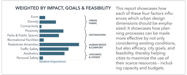
The State of Place Walkability Evaluation found that the area currently has a walking score of 33 out of 100—a low but unsurprising number. In comparison, Downtown Tigard scored 66.
The graphic below shows which urban features the city could focus on that would improve the Triangle’s score, are in keeping with the community’s vision, and are within the city’s control. With this in mind, we are excited to consider ways to improve pedestrian amenities, traffic safety, and overall aesthetics in the Triangle and to apply this analysis to the types of projects that could be funded by tax increment financing.

